| Foto |
Datei |
Credits |
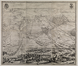
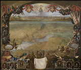
| 2014_mapping-spaces_jacques- callot_landkarte-
belagerung-von- breda_001.jpg |
Mapping Spaces.
Networks of Knowledge in the Landscape Art of the 17th Century
Jacques Callot, aereal perspective map of the siege of Breda 1624–1625
around1627
engraving, 125,5 x 147 cm
Staatliche Kunsthalle Karlsruhe
|
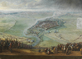
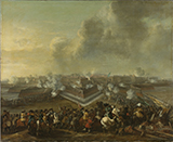
| 2014_mapping-spaces_pieter-snayers_die-
belagerung-von-gravelines_002.jpg |
Mapping Spaces.
Networks of Knowledge in the Landscape Art of the 17th Century
Pieter Snayers, The siege of Gravelines from April 11 to May 17, 1652
around 1653
oil of canvas, 188 x 260 cm
Photographic Archive, Museo Nacional del Prado, Madrid
|
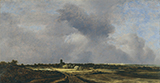
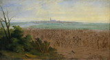
| 2014_mapping-spaces_jacob-isaacksz-van- ruisdael_
ansicht-von-naarden_003.jpg |
Mapping Spaces.
Networks of Knowledge in the Landscape Art of the 17th Century
Jacob Isaacksz Ruisdael, View on Naarden
1647
oil of canvas, 34,8 x 67 cm
Museo Thyssen-Bornemisza, Madrid
|
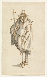
| 2014_mapping-spaces_david- vinckboons_
ein-geograf_004.jpg |
Mapping Spaces.
Networks of Knowledge in the Landscape Art of the 17th Century
David Vinckboons, A geographer
no year
pen and ink drawing, 17,4 x 10,3 cm
Königliche Kunstmuseen Belgiens, Brussels
|
| 2014_mapping-spaces_david-teniers-der- juengere_
ansicht-stadt-valenciennes_005.jpg |
Mapping Spaces.
Networks of Knowledge in the Landscape Art of the 17th Century
David Teniers the Younger, View of the city Valenciennes
1656
oil of canvas, 177 x 205 cm
Koninklijk Museum voor Schone Kunsten, Antwerpen |
| 2014_mapping-spaces_pieter- wouwerman_die-
stuermung- coevordens_006.jpg |
Mapping Spaces.
Networks of Knowledge in the Landscape Art of the 17th Century
Pieter Wouwerman, The storming of Coevordens on december 30, 1672
1672–1682
oil of canvas, 65,5 x 80,5 cm
Rijksmuseum, Amsterdam |
| 2014_mapping-spaces_adam-frans-van-der- meulen_
die-truppen-von-ludwig-xiv-vor- naarden_007.jpg |
Mapping Spaces.
Networks of Knowledge in the Landscape Art of the 17th Century
Adam Frans van der Meulen, The troops of Louis XIV. In front of Naarden on July 20, 1672
1672 – 1690
oil of canvas, 52 x 93,5 cm
Rijksmuseum, Amsterdam |
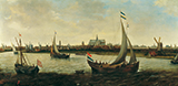
| 2014_mapping-spaces_hendrick-cornelisz- vroom_
ansicht-von-haarlem_008.jpg |
Mapping Spaces.
Networks of Knowledge in the Landscape Art of the 17th Century
Hendrick Cornelisz Vroom, View onHaarlem from Noorder Buiten Spaarne,
around 1625
oil of canvas, 61 x 122,5 cm
Frans Hals Museum, Haarlem |
| 2014_mapping-spaces_paul- pfinzing_methodvs-
geometrica_009.jpg |
Mapping Spaces.
Networks of Knowledge in the Landscape Art of the 17th Century
Paul Pfinzing, Methodvs Geometrica
1598
board XXX, colorized woodcut
National library Bamberg |
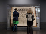
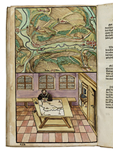
| 2014_mapping-spaces_johannes- klencke_
klencke-atlas_010.jpg |
Mapping Spaces.
Networks of Knowledge in the Landscape Art of the 17th Century
Johannes Klencke, Klencke Atlas
(1613-) 1660
Exhibition view Mapping Spaces
Book with wall map
The British Library
Photo: Felix Grünschloß
© ZKM | Karlsruhe |
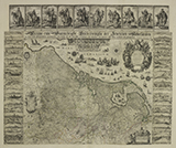
| 2014_mapping-spaces_johann-willemsz- blaeu_
beschrijvinghe-der-zeventien- nederlanden_011.jpg |
Mapping Spaces.
Networks of Knowledge in the Landscape Art of the 17th Century
Johann Willemsz. Blaeu, [...] Beschrijvinghe der Zeventien Nederlanden [...]
In: Johannes Klencke, Klencke Atlas (1613-) 1660
Buch mit Wandkarten
The British Library
© The British Library Board K.A.R. (11) |


